Manchester, a vibrant metropolis steeped in history and culture, boasts a modern and efficient transportation system that makes navigating the city a breeze. At the heart of this system lies the Manchester tram network, a crucial component of the city’s public transit infrastructure.
The Manchester tram map serves as a guide for residents and visitors alike, offering convenient access to key destinations across the Greater Manchester area.
The Evolution of Manchester’s Tram Network
Manchester’s tram network has a rich and storied history that reflects the city’s growth, technological advancements, and shifting transportation needs over the decades. From its humble beginnings with horse-drawn trams to its resurgence as a modern light rail system, the evolution of Manchester’s tram network is a testament to the city’s adaptability and commitment to sustainable urban mobility.
Early Beginnings: Horse-Drawn Trams
The roots of Manchester’s tram network can be traced back to the late 19th century when horse-drawn trams first began operating in the city. Introduced in 1877, these trams provided a vital mode of transportation, connecting various neighborhoods and facilitating the movement of goods and people within the rapidly expanding urban landscape.
Horse-drawn trams were a common sight on Manchester’s streets, characterized by their distinctive appearance and rhythmic clatter as they traversed the city.
The Transition to Electric Trams
As technology advanced, Manchester’s tram network underwent a significant transformation with the introduction of electric trams in the early 20th century.
The electrification of the tram system brought about several advantages, including increased speed, efficiency, and capacity.
Electric trams became a popular mode of transportation, offering a more comfortable and reliable alternative to their horse-drawn predecessors.
During this period, Manchester’s tram network experienced a period of expansion, with new routes being added to accommodate the city’s growing population and urban sprawl.
The electrified tram network became an integral part of daily life for Manchester residents, providing essential connections between residential areas, commercial districts, and industrial zones.
Decline and Resurgence
Despite its initial success, Manchester’s tram network faced challenges in the mid-20th century as the popularity of automobiles and buses grew, leading to a decline in tram ridership.
Economic factors, changes in urban planning, and the perceived limitations of tram technology contributed to the gradual phasing out of tram services in many cities, including Manchester.
However, as concerns about traffic congestion, pollution, and urban sprawl intensified in the late 20th century, cities around the world began reevaluating the role of trams in their transportation systems. Manchester was no exception.
Recognizing the need for sustainable and efficient transportation options, city planners embarked on an ambitious project to reintroduce trams to the city.
The Launch of Metrolink
In 1992, Manchester’s tram network was reborn with the launch of Metrolink, a modern light rail system that would revolutionize public transportation in the Greater Manchester area.
The introduction of Metrolink represented a significant milestone in Manchester’s transportation history, signaling a shift towards a more sustainable and integrated approach to urban mobility.
Metrolink initially began with a single line connecting Bury to Manchester city center, but it quickly expanded to serve additional routes and destinations across the region. The system’s success spurred further investment and expansion, with new lines being added to accommodate growing demand and improve connectivity.
Today, Metrolink stands as one of the largest light rail networks in the United Kingdom, spanning over 90 kilometers of track and serving millions of passengers each year.
Its extensive network of routes connects major employment centers, cultural attractions, educational institutions, and residential areas, offering commuters and visitors alike a convenient and environmentally friendly way to navigate Manchester and its surrounding suburbs.
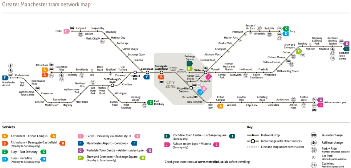
The Modern Manchester Tram Map
Today, the Manchester tram map spans over 90 kilometers (56 miles) of track, serving an extensive network of routes that connect key areas within Greater Manchester. The map outlines the various tram lines, stops, and interchange points, providing passengers with a comprehensive overview of the system.
The Manchester tram map features several distinct lines, each offering access to different parts of the city and beyond:
- Altrincham Line: Connecting Altrincham in the southwest to the city center, this line serves popular destinations such as Old Trafford, home to Manchester United Football Club.
- Ashton-under-Lyne Line: Running eastward from the city center to Ashton-under-Lyne, this line provides access to attractions like the Etihad Stadium, home of Manchester City Football Club.
- Bury Line: Serving the northern suburbs, the Bury line extends from Bury to Manchester city center, passing through areas rich in industrial heritage.
- East Didsbury Line: Stretching to the southern suburbs, this line links East Didsbury to Manchester city center, with stops near the University of Manchester and Manchester Business School.
- Eccles Line: Connecting Eccles to Manchester city center, this line offers convenient access to MediaCityUK, a major hub for media and digital industries.
- Manchester Airport Line: Providing a direct link between Manchester Airport and the city center, this line facilitates seamless travel for both residents and visitors.
Manchester with the Tram Map
The Manchester tram map serves as an invaluable resource for navigating the city’s diverse neighborhoods and attractions. Whether you’re a commuter traveling to work, a tourist exploring cultural landmarks, or a resident running errands, the tram network offers a convenient and efficient mode of transportation.
Passengers can easily plan their journeys using the tram map, identifying the nearest tram stop to their starting point and selecting the appropriate line to reach their destination. With frequent services running throughout the day and into the evening, the tram network ensures reliable connectivity across Greater Manchester.
Conclusion
As one of the cornerstones of Manchester’s transportation infrastructure, the Manchester tram network plays a vital role in facilitating mobility and connectivity across the city. With its user-friendly tram map guiding passengers every step of the way, navigating Manchester has never been easier.
Whether you’re commuting to work, exploring the city’s attractions, or simply enjoying a day out, the tram network offers a convenient and efficient way to travel in Manchester.